
Hazlet ZIP Code Coverage
The county postal list gives Hazlet Township one principal pairing and shows several nearby postal places that can complicate an address search. The list directly pairs Hazlet with 07730. It also identifies Keansburg, New Monmouth, and Keyport as distinct post-office labels. West Keansburg is a Hazlet section associated in local material with the Keansburg 07734 postal area, but a particular street still needs address-level verification before that ZIP is treated as its delivery result.
| Postal code | Area described by the county list | Post office | Research note |
|---|---|---|---|
| 07730 | Hazlet Township's principal postal area | Hazlet | Most Hazlet addresses are expected in this postal area. |
| 07734 | West Keansburg section and nearby Keansburg postal area | Keansburg | Use address-level postal verification for a particular street. |
| 07748 | Nearby New Monmouth postal place | New Monmouth | Not listed as Hazlet proper; relevant to neighboring-address confusion. |
| 07735 | Keyport postal area near Hazlet's northern edge | Keyport | Not a Hazlet ZIP, but may arise in boundary or historical searches. |
Monmouth County's official ZIP and post-office list is the source for the listed Hazlet and nearby postal pairings.
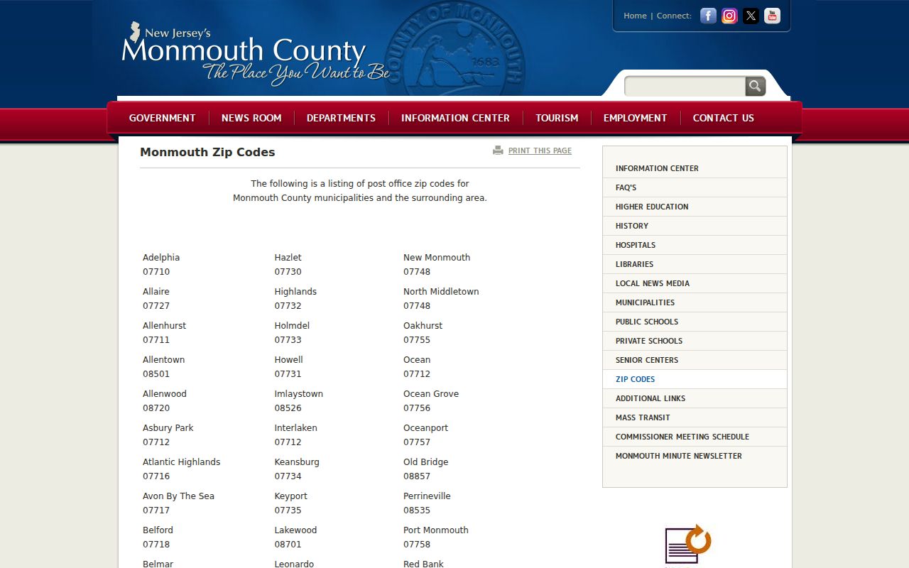
The list is a strong starting point for postal names, but it is not a street-by-street delivery map or a municipal-boundary record.
Hazlet's 07730 Postal Area
07730 is the principal delivery code in the Hazlet postal directory because the county's official list pairs it with Hazlet. That pairing helps interpret a return address or a record that uses a postal city. It does not mean every document with the word Hazlet, or every parcel close to a Hazlet line, falls within Hazlet Township. Postal labels route mail. Township boundaries determine the local government, tax roll, permits, and land-record municipality to search.
For a current parcel, preserve the ZIP with the address exactly as the source returns it. Then compare the street and municipality against the Monmouth tax or GIS system. For a historical item, retain the document date too. A later postal convention can differ from the municipal name used in an older deed, directory, or minute book. This distinction keeps a 07730 result from becoming an unsupported claim about jurisdiction or residence.
West Keansburg's 07734 Exception
West Keansburg is the key exception in a Hazlet postal-area search. Official Hazlet materials identify West Keansburg as a township section, while the county post-office list assigns 07734 to Keansburg. The research did not capture an official Postal Service result for a specific West Keansburg street or an exact delivery-boundary polygon. For that reason, 07734 is a documented local postal exception, not a shortcut for defining the township line.
Check the complete street number with the Postal Service's ZIP Lookup, then check the legal municipality with the county parcel system. If the two sources use different place names, keep both in the research notes and identify which source supplied each value. That approach is more accurate than rewriting a Keansburg postal label as Hazlet or the reverse.
Note: The county list identifies post-office pairings, while a postal lookup confirms delivery for one complete address on the date checked.
Search a Hazlet ZIP Code Carefully
No inspected county property or voter interface supplied a public ZIP-wide resident filter for Hazlet. That limitation matters. Monmouth OPRS works through address, owner, municipality, year, and block-and-lot choices, while the New Jersey voter tool asks for an individual registration match. Use the delivery code to verify and narrow an address, then move to the record system that actually keys the parcel or person.
- Keep the full postal address as written, including the leading zero in the five-digit delivery code and any unit information.
- Verify the delivery ZIP for the exact street number through the Postal Service lookup, then record the date of that result.
- Use the county tax address mode with Hazlet Township and the relevant tax-list year to obtain the block, lot, and property location.
- Compare the parcel in Monmouth GIS and use the block and lot in the deed index where a recorded transfer needs review.
- For an individual registration question, use the state voter search with the name, county, and municipality rather than treating a ZIP as a voter-list filter.
Once the postal area has been narrowed to a road, the Hazlet street directory has the full address-to-parcel and deed-chain workflow. It is the better route for one street or parcel.
Use Hazlet Parcel Keys Beyond Postal Codes
In county property records, the reproducible location key is the municipality plus block, lot, and qualifier, not the postal code. The Tax Assessor's current tax-map instructions direct users to search by street address or block and lot. Monmouth MOD-IV then supplies the parcel-card layer, which can show property location, owner, mailing city and state, assessment information, year built, class, zone, acreage, taxes, and tax-list history when populated.
The Monmouth MOD-IV property-search interface is the county source used to move from an address to a parcel record. A mailing city or state is correspondence information, not proof that the assessed owner lives at the property. Daniel's Law can also redact identifying data for covered people while leaving the parcel record visible.
The MOD-IV property-search screen shows the county entry point for address, owner, and block-and-lot research around Hazlet.
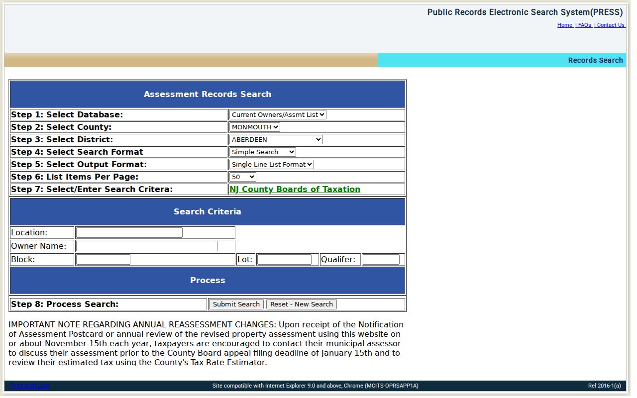
Use the displayed property location and parcel fields to test municipal placement after a postal code has narrowed the address.
Hazlet ZIP Code Search Fields
The absence of a ZIP filter does not make the county systems less useful. It tells the researcher which fields are authoritative for the next step. The OPRS tax-list index uses the selected municipality and year with an address, owner, or parcel mode. Those inputs support a repeatable property search when a postal code alone is too broad or crosses a boundary.
| OPRS field | Why it matters after ZIP verification |
|---|---|
| Street name | Required in address mode and more precise than a postal area for a property lookup. |
| Township | Select Hazlet Township to distinguish the legal municipality from nearby postal places. |
| Year | Choose the tax-list year needed for the record; the portal controls the available years. |
| Owner name | Use the indexed spelling in owner mode when a recorded party name is known. |
| Block and lot | Use the parcel identifiers from the map or deed; qualifier is optional where applicable. |
Monmouth GIS and the state's parcel guidance likewise center on address, county, municipality, and block-and-lot information. A postal code is therefore a discovery and delivery check, not a substitute for the parcel key.
Compare Hazlet ZIP Codes to Boundaries
Postal geography and legal geography overlap but are not the same thing. A ZCTA is a Census Bureau statistical representation of a five-digit postal area, not the exact Postal Service delivery route. The research located no official Hazlet ZIP-by-ZIP resident count, voter count, full route-level boundary map, split year, or realignment year. Do not fill those gaps with estimates or map lines from an unrelated source.
- Postal code
- A Postal Service delivery code used with an address. It is not a municipal-boundary designation.
- ZIP+4
- An added delivery segment used to refine a mailing address beyond the five-digit base code.
- PO-box ZIP
- A ZIP assigned for post-office-box delivery. It does not establish the municipality of a physical parcel.
- Unique ZIP
- A ZIP associated with one organization or institution. No Hazlet-specific unique ZIP was verified in the research.
- Carrier route
- A delivery sequence used by the Postal Service. It is not a resident directory or a legal parcel boundary.
Read Hazlet ZIP Code History with Names
Historic research requires a date-aware place name. The land that became Hazlet was part of Middletown until 1848, then Raritan Township from 1848 until the 1967 rename to Hazlet Township. A historic deed, census entry, minute book, or postal reference can therefore use Middletown or Raritan rather than Hazlet. Search the municipality appropriate to the date before deciding that a postal mismatch is an indexing error.
The local road history offers the same lesson. Lynn Boulevard was formerly Aumack Lane, and the former farmland later became Raritan Ridge Estates. A dated legal description and tax-map parcel key are more dependable bridges than a modern postal label. No complete official Hazlet street-renumbering or ZIP-realignment table was located, so a missing match should lead to a custodian or archive check instead of a guess.
Apply the Hazlet ZIP Code Boundary Rule
For any address near Hazlet, record the postal ZIP exactly as returned, confirm the municipality through the county parcel or tax system, and preserve the source date. Keep the street number, unit, postal city, and state abbreviation with the result. If a historical source uses a different place name, preserve that original wording alongside the modern parcel reference.
Boundary rule. Treat a ZIP as delivery geography, then use the Hazlet Township parcel record and legal description to establish municipal placement.
This method avoids a common error around West Keansburg and the nearby New Monmouth and Keyport postal areas. It also leaves a clear path when a county list, postal result, map layer, and historic document do not use the same label.
For a current location question, the county tax map and GIS parcel viewer are the practical municipal checks after the delivery ZIP has been verified. Their parcel geometry and layers should be treated as current-data tools, not a legal survey. For an older address, Hazlet's 1901 through 1998 municipal material is held at Monmouth County Archives, while earlier Hazlet work may be indexed under Raritan Township or Middletown. The county land index has separate online cutoffs by document type, so a missing deed result can require the County Clerk counter or State Archives microfilm rather than a wider ZIP search.